
 The Lunar and Planetary Sciences Conference is coming up in a couple weeks. I unfortunately will not be attending but the abstracts for the conference, which are almost mini-papers in length, have been online for a few weeks now. Nearly all the Io-related abstracts are for posters to be presented on the evening of Tuesday, March 11. In this post, and in blogs to be posted over the next week or so, I will cover one of the abstracts for this conference.
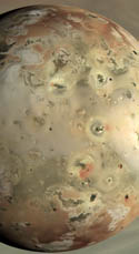
The first abstract I'm going to discuss is "Geologic Mapping of the Zal Region of Io" by Melissa Bunte, David Williams, and Ron Greeley. This abstract covers work done as a part of series of geologic mapping work performed by the Planetary Geology group at Arizona State University on the mosaics Galileo acquired of Io during its seven encounters. This time they cover the area around Zal Patera. This volcano on Io's northern Leading hemisphere is bounded to the west and south by the two-part Zal Montes.
Like most places the group has mapped, they found 5 basic terrain types: plains, mountains, patera floor materials, flow materials, and diffuse materials. Their mapping allowed the authors to determine the age relationships between the different flow units within Zal Patera based on the brightness of the flows. Basically, as a flow ages, it cools (obviously) and as it cools, more volatiles can condense on it. Color-wise, the progression at this latitude is (generally now) from black, to green (when you got your sulfur mixing with your iron), to yellow (thanks to S8), and then to red-brown when radiation starts to work on the sulfur and break it down (anyone know how long that roughly takes, by the way?). The group also mapped some very extensive, old flows that they attribute to Rustam Patera, the proposed name for an active volcano on the western margin of South Zal Montes.
Following the work they have done previously in the Amirani and Camaxtli regions on Io, they will like publish this work sometime in the next year or so. Certainly will be a paper to look for. I would be interested in how they handle the connection between Rustam Patera and the lava channel that runs north from it up through to what they identify as a fissure along the western margin of Zal Patera. Another interesting feature in this region (or actually just off the western edge of their mapped segment) is a small, explosive eruption from the summer of 1997 that produced a small dark pyroclastic deposit that partly overlaps onto the western margin of the North Zal Montes plateau, which is identified as a flow (?) in the map included in the abstract, and a bright ring around that pyroclastic deposit. Strangely enough, no obvious effusive materials from that eruption.
The ASU group also has another poster at the conference where they present the work they have done so far on producing a global geologic map. I will discuss that abstract in a later post.
Link: Geologic Mapping of the Zal Region of Io [www.lpi.usra.edu][pdf file]


No comments:
Post a Comment