
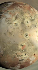
 Continuing the project I started last month, I have posted on my Io images page several more Io maps from several of Galileo's orbits, including from G1, C3, G29, and I31. These maps help illustrate some of the surface changes documented by Galileo during its six years of observations while in orbit around Jupiter. For example, comparing the maps from G29 and I31 (shown at right), you can see several new plume deposits, including a bright ring around Thor (which was undergoing a major eruption during August 2001), a red ring around Dazhbog, and a faint deposit around Surt (probably a faded red ring from the major eruption that took place in February 2001, still the most powerful volcanic eruption ever witnessed).
I am still considering producing some sort of product that combines these and other maps of Io as layers in a photoshop file for example. Photoshop isn't quite ArcGIS, but it'll do.
Link: Galileo images of Io [pirlwww.lpl.arizona.edu]


No comments:
Post a Comment